January 2024 Prediction: Colder Temperatures and More Snow
- 828weather
- Dec 22, 2023
- 1 min read
Major pattern change begining the end of December and continuing through January/February 2024!
Winter 2023/2024 Summary (through 12/22/2023)
Winter in the High Country has been 1-3 degrees warmer than normal and we have experienced below normal snowfall as of 12/22/2023 (see temperature anomaly map below). Most of this winter we have seen persistent ridging aloft favoring above normal temperatures and few opportunities for snow.

Global pattern change end of 2023
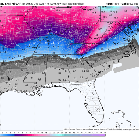
The persistent ridging aloft we have experienced so far will transition to greater upper level troughing which favors colder air in addition to a more active stormier pattern. Long range models are suggesting this pattern change will continue through at least February. We will see the first hint of the pattern change next week when an upper low passes through the region, followed by a period of northwest flow snow (see ECMWF Total Snow Map below).

Models long range temperature and snowfall forecast
Below are European Model temperature and snowfall maps for January 2024. Our temperatures are 3 degrees or more below normal, with modeled snowfall amounts of around 12". Snowfall amounts are estimates, and with the forecasted pattern change to greater upper level troughing, we have the potential for more snow events which would add to these totals.


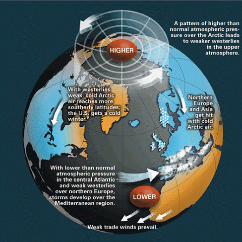
Why are global wave patterns changing?
AO (Artic Oscillatio) flips from positive to negative at the end of the month and stays through January. A negative phase of the AO allows cold air to plunge into the Eastern United States.
The last three El Nino winters had their coldest, stormiest periods in February.
Other factors such as stratospheric warming (not discussed in this post).


Comments